

At the 2026 HERE Directions event in Melbourne, Andrei Iordache, Senior Director Automotive Presales at HERE Technologies, outlined how mapping and location data are evolving from simple navigation tools into a critical digital infrastructure layer for the transport and mobility ecosystem.
His presentation explored how advances in artificial intelligence, real-time data collection, and cloud connectivity are transforming maps into dynamic platforms capable of supporting autonomous vehicles, connected fleets, and increasingly complex logistics operations.
Location intelligence enters the AI era
Iordache began by describing a new generation of intelligent transport systems where vehicles interact directly with digital infrastructure. Instead of simply displaying information on a map, vehicles and drivers will increasingly ask questions and receive real-time answers from AI systems.
For example, a truck driver might ask whether there are road restrictions ahead on the planned route. In this scenario, the system must analyse multiple layers of data—maps, road rules, vehicle restrictions, traffic conditions, and weather—to deliver an accurate response instantly.
This type of interaction highlights how location intelligence is becoming a core decision-making layer for mobility systems rather than just a visual interface.
Six trends reshaping location technology
According to Iordache, six major trends are influencing the future of mapping and mobility platforms:
1. Agentic AI
Conversational AI assistants are increasingly integrated into vehicles and transport systems, allowing users to interact with maps and location services through natural language queries.
2. Autonomous mobility
Self-driving vehicles are moving beyond pilot programs in many cities, increasing the demand for highly accurate and constantly updated mapping data.
3. Virtualisation in automotive software
Vehicle software is shifting from static releases to continuous development environments using simulation and virtual testing platforms.
4. Complex user experiences
Drivers now interact with maps across multiple devices and interfaces—from smartphones to dashboards and back-end systems—creating challenges in delivering a seamless experience.
5. Pressure for differentiation
Automotive manufacturers and mobility providers increasingly rely on location-based services to differentiate their products and services.
6. Mapping as a service
Maps are evolving from static files into cloud-based services that are continuously updated and personalised for different users and applications.
Together, these trends are pushing mapping technology towards real-time, cloud-delivered platforms that support both vehicles and enterprise logistics systems.
The importance of high-quality data
A central theme of the presentation was the importance of data quality in AI systems.
“If you have bad data, you’ll have bad outcomes,” Iordache explained, emphasising that AI models rely heavily on the accuracy and richness of underlying datasets.
To address this challenge, HERE Technologies aggregates data from a wide ecosystem that includes:
- Connected vehicle sensors and perception data
- Geospatial data collection teams around the world
- Global fleet telemetry
- Smart devices and user feedback
Millions of vehicles now contribute data that helps update the digital map of the world in near real time.
From static maps to living digital infrastructure
Traditional map development followed a linear process—capture data, process it, and release updates periodically.
Modern mapping platforms operate very differently.
HERE now uses what it describes as a feedback-driven architecture, where data flows continuously between vehicles, applications, and the mapping platform. Changes detected on the road are verified and integrated into the map before being redistributed through cloud services to vehicles and devices.
This means the map effectively becomes a living digital asset, continuously updated rather than periodically refreshed.
Streaming technology also allows maps to be delivered directly from the cloud to vehicles rather than stored locally on physical media, dramatically improving update speed and accuracy.
Supporting safer and smarter vehicles
One practical application of this approach is the development of advanced speed-limit intelligence.
Using vehicle perception data and automated analysis, HERE can update speed-limit information far more frequently than traditional mapping methods. Updates that previously took days can now occur multiple times per day, improving accuracy for technologies such as Intelligent Speed Assistance.
This capability is increasingly important as regulatory frameworks—particularly in Europe—require highly accurate speed-limit recognition systems in vehicles.
Enabling smarter logistics and delivery
Beyond automotive applications, HERE is also focusing on enterprise solutions for transport, logistics, and fleet operations.
Key innovations include:
Truck-specific mapping – Detailed data on bridge heights, truck restrictions, parking areas, and industrial points of interest.
Micro-point addressing – Location intelligence that identifies the exact delivery entrance or loading dock rather than simply a street address.
Route optimisation tools – Integrated solutions that connect dispatch systems, driver navigation, and back-end analytics using the same underlying map.
These capabilities allow organisations to optimise route planning, improve estimated arrival times, and analyse driver performance across entire fleets.
The result is a more integrated ecosystem where planning systems, drivers, and logistics platforms all operate from the same location data foundation.
Preparing for an AI-driven mobility future
As artificial intelligence becomes embedded across transport systems, Iordache believes location intelligence will become one of the most important digital infrastructure layers supporting mobility.
Maps will no longer be passive reference tools. Instead, they will power real-time decision-making across vehicles, logistics platforms, and autonomous systems.
His key message to the audience was clear: the future of mobility will rely on accurate, continuously updated location data combined with AI-driven analytics.
“Location is no longer just for humans,” Iordache said. “It is becoming part of the decision layer for automated systems.”
For fleet operators, logistics companies, and automotive manufacturers, this shift represents a major opportunity. Those able to harness real-time location intelligence will gain a powerful advantage in improving safety, efficiency, and customer service across the transport ecosystem.
- Hyundai expands STARIA Load range with hybrid power and fleet-focused upgrades
 Hyundai has given its STARIA Load commercial van its most significant update since launching in Australia in 2021, introducing a new hybrid powertrain while refining the vehicle’s ride, cabin technology and comfort for fleet operators. Speaking at the Australian launch, Michael Croan, Product Planning Assistant Manager at Hyundai, said the updated STARIA Load builds on
 - June sales surge changes the fleet equationAustralia’s new-car market has delivered a landmark month that will reshape fleet conversations about residual values, replacement cycles and the pace of electrification. June 2026 was the strongest month ever for Australian new-vehicle sales, with 140,058 vehicles sold from all sources. VFACTS recorded 131,134 sales, up seven per cent on June last year, while battery-electric
- NSW RFS fleet reform is the biggest fleet management shake-up since StateFleet was disbandedThe NSW Government’s decision to transfer ownership and management of the Rural Fire Service fleet from local councils to the RFS is the biggest change in NSW public sector fleet management since StateFleet was disbanded in 2015. As part of the 2026-27 NSW Budget, the Minns Labor Government will invest $470 million over 10 years
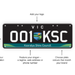
- VicRoads Business Plates Give Victorian Fleets a New Branding OpportunityVictorian businesses can now turn every fleet vehicle into a mobile brand asset with the launch of VicRoads Business Plates, a new personalised number plate product designed specifically for organisations of all sizes. The new offering follows years of demand from the business community and brings Victoria into line with other states where branded number
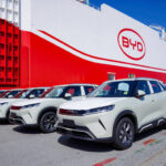
- BYD Targets Top-Three Finish as Growth Accelerates Across Australia and New ZealandBYD Australia and New Zealand has set its sights on becoming one of the country’s top three automotive brands as rapid growth in electric and plug-in hybrid vehicle sales continues to reshape the local market. Speaking at the launch of the BYD Shark 6 Cab Chassis and Shark 6 Performance, Chief Operating Officer Stephen Collins